[Map-Making]
Five Photos Showing the National Geographic Society's Cartographic Endeavors, 1941
Silver prints (5)
Each 6 1/2 by 8 1/2 inches
With affixed caption and stamps verso.
With affixed caption and stamps verso.
Further images
Five charming images showing employees of the National Geographic Society hard at work constructing their widely-disseminated maps, from a photo essay published by the Magazine in 1941. One photo shows...
Five charming images showing employees of the National Geographic Society hard at work constructing their widely-disseminated maps, from a photo essay published by the Magazine in 1941.
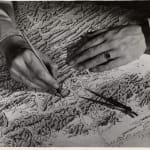
One photo shows a disembodied pair of hands drawing hachures, shaded lines representing the extend and degree of sloping land on a mountain or hill. Another shows a different pair of hands adding the word "Kent" to a map of Maryland. This image is accompanied by the caption "A town is put on the map - literally." Another shows a man hard at work cutting "windows" as part of the layering process of map-making.
One photo shows a disembodied pair of hands drawing hachures, shaded lines representing the extend and degree of sloping land on a mountain or hill. Another shows a different pair of hands adding the word "Kent" to a map of Maryland. This image is accompanied by the caption "A town is put on the map - literally." Another shows a man hard at work cutting "windows" as part of the layering process of map-making.
![[Map-Making], Five Photos Showing the National Geographic Society's Cartographic Endeavors, 1941](https://artlogic-res.cloudinary.com/w_1600,h_1600,c_limit,f_auto,fl_lossy,q_auto/artlogicstorage/dollc/images/view/a7726c4124425a5688cf06ce3de91a9cj/daniel-oliver-map-making-five-photos-showing-the-national-geographic-society-s-cartographic-endeavors-1941.jpg)
![[Map-Making], Five Photos Showing the National Geographic Society's Cartographic Endeavors, 1941](https://artlogic-res.cloudinary.com/w_1600,h_1600,c_limit,f_auto,fl_lossy,q_auto/artlogicstorage/dollc/images/view/ad167db7a0d10396deac8e240fe9c47aj/daniel-oliver-map-making-five-photos-showing-the-national-geographic-society-s-cartographic-endeavors-1941.jpg)
![[Map-Making], Five Photos Showing the National Geographic Society's Cartographic Endeavors, 1941](https://artlogic-res.cloudinary.com/w_1600,h_1600,c_limit,f_auto,fl_lossy,q_auto/artlogicstorage/dollc/images/view/9cce12e9eda260035a90642cff5c3f9fj/daniel-oliver-map-making-five-photos-showing-the-national-geographic-society-s-cartographic-endeavors-1941.jpg)
![[Map-Making], Five Photos Showing the National Geographic Society's Cartographic Endeavors, 1941](https://artlogic-res.cloudinary.com/w_1600,h_1600,c_limit,f_auto,fl_lossy,q_auto/artlogicstorage/dollc/images/view/a596d53fc2ae6986ae7596f7353f0994j/daniel-oliver-map-making-five-photos-showing-the-national-geographic-society-s-cartographic-endeavors-1941.jpg)
![[Map-Making], Five Photos Showing the National Geographic Society's Cartographic Endeavors, 1941](https://artlogic-res.cloudinary.com/w_1600,h_1600,c_limit,f_auto,fl_lossy,q_auto/artlogicstorage/dollc/images/view/89956636588f4057130bbb029655f52dj/daniel-oliver-map-making-five-photos-showing-the-national-geographic-society-s-cartographic-endeavors-1941.jpg)


