


Aristocrat, Inc.
Sprawling, 16 Foot Strip Map of the West Coast from Vancouver to Tijuana, 1931
Color and photo-lithograph
9 x 201 inches
Folded into black stiff printed wrappers.
Folded into black stiff printed wrappers.
Sold
Further images
-
(View a larger image of thumbnail 1
)

-
(View a larger image of thumbnail 2
)

-
(View a larger image of thumbnail 3
)

-
(View a larger image of thumbnail 4
)

-
(View a larger image of thumbnail 5
)

-
(View a larger image of thumbnail 6
)

-
(View a larger image of thumbnail 7
)

-
(View a larger image of thumbnail 8
)
-
(View a larger image of thumbnail 9
)

-
(View a larger image of thumbnail 10
)

-
(View a larger image of thumbnail 11
)

-
(View a larger image of thumbnail 12
)

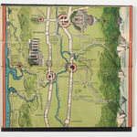
This incredible (and incredibly long) strip map - almost 16 feet in length - was published by the Aristocrat Inc. of Portland, Oregon, in 1931. Sold with an original price...
This incredible (and incredibly long) strip map - almost 16 feet in length - was published by the Aristocrat Inc. of Portland, Oregon, in 1931. Sold with an original price tag of 75 cents, the map offers a fun and colorful overview of the primary roads from Vancouver to Tijuana. Topography is illustrated pictorially, along with vignettes representing major locations of interest, notable geographic features, mileages, cities and towns, mountains, historical spots, hunting and fishing spots, hiking trails, resorts, hotels and garages. The verso is heavily illustrated with information on scenic attractions, garages and hotels along the highway routes
As per the text on the front cover, the map makes a splendid souvenir and when finished with it, one ought to “mail it to a friend or shut in.”
As per the text on the front cover, the map makes a splendid souvenir and when finished with it, one ought to “mail it to a friend or shut in.”